The desert in the Sinai is very diverse with many different faces. There are wide open plains and high sand dunes, surrealistic sandstone hills and rocks carved by winds, flat topped ranges and plateaus offering dramatic views, rugged mountains and a maze of long winding wadis, green oases and hidden canyons. There are also a number of sites of archaeological interest, from Byzantine, Pharaonic and Nabatean times.
The Colored Canyon
The Colored Canyon is the best known of all the canyons in the Sinai. It runs between steep walls displaying a palette of incredible colors and rock formations, starting off from a plateau and ending at a sandy wadi. Running parallel to it is another sandy wadi, from which another lesser known canyon starts.
Jebel Mileihis
Jebel Mileihis is a flat sandstone mountain towering over the desert, with views as far as the sea at Nuweiba. There are springs with date palms, MoyatMileihis, at its foot in a tranquil setting. Wadi Disco, named after the Bedouin parties held here, is a small settlement close to the mountain.
Ein Hodra oasis
Ein Khudra, meaning Green Spring, is a picturesque oasis with gardens and date palms, encircled by steep mountain ranges and vertical cliffs. It is very easy to reach from the main road. There are springs here – one of them is in a small cave, another overflowing from a fountain – which sustain a number of gardens. There are also ruins of archeological interest in the area.
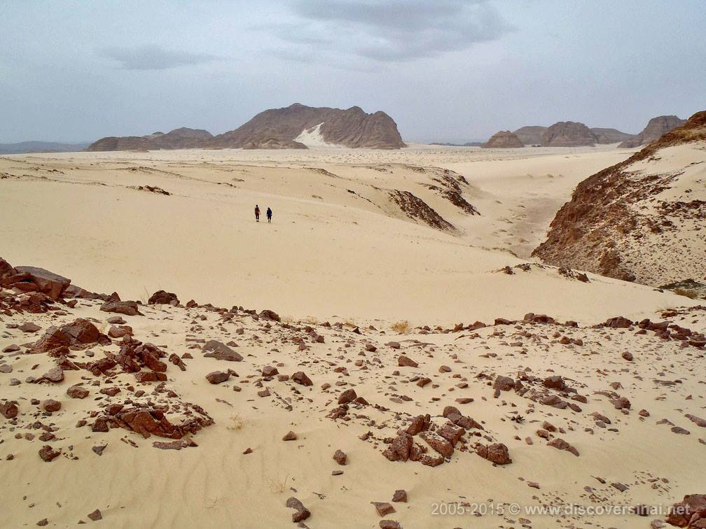
The White Canyon
Starting as a crack at the edge of a sand plateau, it is a narrow sandstone canyon, opening to a wider wadi and leading to the oasis of Ein Khudra. A little climbing is involved at places.
Nawamis Site
Mysterious prehistoric stone buildings, dating back to the Copper Stone Age (4000-3150 BC), which are only found in South Sinai, in several areas. They are believed to be ritual burial chambers, always located at elevated points and facing west. This is the biggest and best-preserved site.
Jebel Matamir
A group of elongated sandstone hills, rising from a sandy plain and separated by wadis. There are steep sand dunes running from some parts of the mountains. From the peaks of Gebel Matamir there are far reaching views of the sand desert and distant high mountain ranges.
Jebel Barqa and Jebel Makharum
The popular sandstone formation of Jebel Makharum, with a hole cutting through it, is only one of the many curious rock formations and hills of the sandstone range called Jebel Barqa. There are also many small caves, sand dunes and rock formations offering stunning views from the top.
Haduda sand dune
The high sand plateau around Jebel Barqa suddenly comes to an end at Haduda sand dune, where it drops steeply about 150 meters to a rocky wadi running towards the coast. Magnificent views, but also a place to have fun and get sand all over you!
Bier Safra and Dune at Safra
A well, with clean water, in the desert at the crossing of main routes. The rock formation and high sand dune are a short distance away and clearly visible from the well. A new garden is being developed to provide a pleasant stop.
Arada Canyon (Double Canyon)
There are actually two canyons, branching off from the same entrance and connected via a small plateau, forming a circuit. It involves some climbing and little help might be needed at tricky parts. Its entrance is located in a secluded sandy stretch of a gully.
Guna Plateau
A long, flat mountain range separating two main wadis from which gullies descend to all directions. From the rim of the plateau there are stunning views of the sand desert around dotted with sandstone outcrops and distant rugged ranges, including Mt. Katherina. Several canyons are located at its base.
Blue Desert
An open desert plain close to the town of St. Katherine, encircled by rugged mountain ranges, made famous by having several outcrops and rock formations painted blue by Belgian artist Jean Verame to commemorate the peace agreement between Egypt and Israel.
Ein Kid oasis
It is a secluded and remote oasis between St. Katherine, Dahab and Sharm el Sheikh, with only a handful of Bedouin living there. Approachable only on foot from St. Katherine and a via a one-way 4×4 track from the Sharm-Dahab road, it remains largely untouched offering a feel of what a real oasis is used to be. There is not much to see and do, apart from enjoying the setting and having an Bedouin tea, but that’s what gives its authenticity and character. Cars cannot drive all the way to the oasis and you will have to walk about 10 minutes.
Wadi Isla
A long and winding wadi along the main caravan route connecting the center and the port city of El Tur. It is narrow and lush towards the end, with many date palms, canes, trees and a creek disappearing through a famous precipitous gorge. The sight of the massive floodplain and the sea from the mouth of Wadi Isla is also very dramatic.
Wadi Feiran
The biggest oasis of South Sinai, runningalong the main road for 6 kilometers.There are some important cultural andhistorical sites within the oasis, alllocated close to each other and to thecommercial center. Three gardens andthe Convent of Feiran offeraccommodation. The impressive GebelSerbal massif towers above the oasis.
Wadi Mukattab: The Valley of Inscriptions
Historic sight in beautiful natural setting – Wadi Mukattab, the valley ofthe inscriptions, is in an open sandy area along the off-road route to Serabit el Khadem from the Wadi Feiran asphalt road. There are ancient scripts on the rock faces for several hundred meters.
Wadi Maghara: turquoise mines
Turquoise was mined at Wadi Maghara from the time of the Pharaohs. There are several caves and one Pharaonic carving. The entrance to the narrow wadi is at the shrine of Sheikh Suliman. The area is close to Wadi Mukattab.
Serabit el Khadem: Temple of Hathor
The most important pharaonic site in the Sinai, it is located where the sandy desert belt below the Tih plateau meets the rocky ranges to the south. The temple of Hathor is on the top of a flat range, offering a magnificent backdrop of the desert to the archaeological site.
Ramlat Hmeyer and Jebel Hmeyer
Ramlat Hmeyer, the “Red Sand”, is a vast desert plain between the dark Serabit ranges and the Tih Plateau. It comes to an end at Jebel Hmeyer which looks like a hill from one side – there is a dramatic drop on the other side though. A 4×4 vehicle can easily drive up to the flat top, there is a good track. Below there is another plain, with curious patterns of red and black sand washed together by occasional rains.
Jebel Fuqa and the Forest of Pillars
The Forest of Pillars is an unusual geological rock formation at the foot of the Tih Plateau. The area is often known as Jebel Fuqa, which is actually a rocky hill nearby. The Forest of Pillars has been badly damaged by tourism, but it is still well worth a visit.
The Tih Plateau
The center of the Sinai is a flat desert highland known as the Tih Plateau. It comes to a sudden and deep drop at a sandy desert belt that cuts across the peninsula coast to coast. Looking at it from the south it is a massive and long rock wall with several protruding heads. A 4×4 can ascend the plateau at certain points. The ridge of the Tih Plateau is roughly the border between North and South Sinai.
Jebel Berqa
An impressive round sandstone mountain rising from the sandy plains and lower hills. The way to the top starts in one of the narrow canyons at its base, but the climb is difficult and dangerous towards the end. The views from the saddle at the top of the canyon, which can be reached fairly easily, also offer nice views to two directions.
Ein Umm Ahmed oasis
One of the main Tarabin oases in South Sinai, in the sand belt running from coast to coast under the Tih plateau along a main dirt road. There are many date palms and several plantations and the place has a remote, wild frontier feel. There are many nawamis buildings in the area and on foot or camel the oasis is connected to a number of beautiful locations.